Every once in a while I stumble on an extremely nice piece of Nevada and American history. This is one of those times and it all revolves around the Newlands Project.
Francis Newlands was a United States Senator from Nevada and he had a dream. He knew Nevada had lots of land, but hardly any was arable land. So, he thought, why not use what water the state had and turn the desert into a farming oasis.
Now this wasn’t a new idea. Other United States Congressmen had tried this before, but large blocks of Eastern Senators defeated it every time. Newlands tried a different approach. Instead of one project, he promoted five projects and a department to oversee these projects and others to come in the future. Despite the large block of votes, he still wasn’t able to get his bill passed until Theodore Roosevelt was elected President. On June 17, 1902 Newlands’ dream became a reality.
One of the first five projects was entitled the Newlands Project. It would divert water from the Carson and Truckee River to farmers in Fallon. Churchill County had 830 residents in 1900. With the completion of the project the county seat alone had grown to 1,000 and the population of Churchill County was 4,649.
The immediate affect of the project was just what it was suppose to be. People rolled into the county to open up new farming lands. But there were fatal flaws. It took three years to get the soil into the condition it needed to be to grow crops. Some farmers left. There was not enough water as the people living at Lake Tahoe refused to part with their water. More people left. A wide variety of crops were tried, like cantaloupe, but few proved successful. Still more people left.
Lake Winnemucca at the end of the Truckee River became a faded memory and Pyramid Lake was shrinking fast. Only the endanger cui-ui fish would save it. Then Reno grew rapidly and large. There was not enough water to go around. A 100 year law suit would eventually settle the matter of who gets what water. That is until the next lawsuit is filed!
Despite these troubles, the Newlands Project left a lasting legacy that dictates the use of the critical water resources of Northwestern Nevada - even to this day. Farming and ranching are going concerns in Fallon and the Fallon area. Lake Lahontan is a popular vacation spot. Winnemucca Lake did disappear, but Pyramid Lake has stabilized.
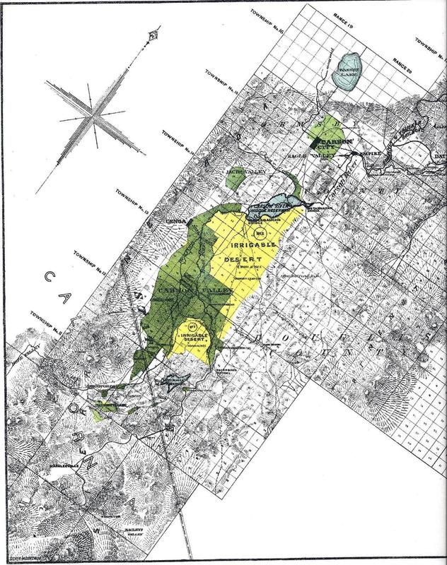
And it all started with the following maps. I found these for sale with a large group of unremarkable topographic maps. At first I thought they were interesting. The second time I looked at them, I saw the stamp, “Submitted by Francis C. Newlands.” They had to do with the Carson and Truckee watersheds. The majority of the maps focused on the Carson River System. This would make sense as the Carson River was the first priority in providing water to Fallon farmers. Later water from the Truckee River would be added.
The maps are obviously at the ‘idea stage.’ For example, they show two dams and reservoirs on the Carson River. Today only the Lake Lahontan Dam and Reservoir exist. The Middle reservoir on this map would have been created west of Carson City. I can not find any historical reference to such a dam. The lower dam and reservoir (about where Lake Lahontan would be) is much smaller than the Middle (or Carson) dam and reservoir. Today Lake Lahontan is quite an imposing water feature.
Also on the primary map there is a large section of irrigatable land shown in yellow. The only identification as to where it is, is the small community of Ragtown. Ragtown is historically important, but it is more interesting that Fallon is not mentioned at all. Fallon would become the center of this project and grow dramatically in the very early 1900’s. But it wasn’t until 1900 that Fallon became a city.
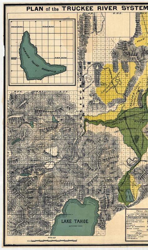
There is a map for the Truckee River featuring the water features of Lake Tahoe, Donner Lake, Pyramid Lake, Sardine Valley Reservoir, and Hennes Pass Reservoir. Today the reservoirs of Boca, Stampede and Prosser help to regulate water usage on the Truckee River in Nevada. Donner has never been considered a real water reservoir for Nevada. Tahoe was at one time, but the citizens objected loudly and clearly. Nevada now gets the top six inches from Lake Tahoe.
There are six maps in this series. The Mary B. Ansari Map Library at the University of Nevada, Reno has at least one of these maps. They attribute the date to 1890, but I found no date on any of the maps. This seems a little early to me. So I did some investigations.
The publisher of the maps was T. K. Stewart of Reno, Nevada. · According to the “Irrigation Papers of the United States Geological Survey, Number 66” he had surveyed a reservoir for Henness Pass in 1890. · He was an 1891 delegate to the Nevada State Irrigation Convention on October 9th. Francis Newlands used maps he had created of the Humboldt, Truckee and Carson Rivers in his presentation to the convention. · Thomas K. Stewart is listed as a civil engineer in the 1904 and 1920 Reno City Directories. · In 1892 he surveyed a canal to run east of Reno to Pyramid Lake to irrigate 25,000 to 30,000 acres of land. He was certainly an early leader in Nevada in creating irrigation projects! · In the early 1890’s he partnered with Francis Newlands in an attempt to create the Riverside Railroad: an electric route from Reno to Lawton Springs.
It seems to me that these easily could be from 1890. If not, they certainly were based on knowledge that Mr. Stewart had gained by 1890!
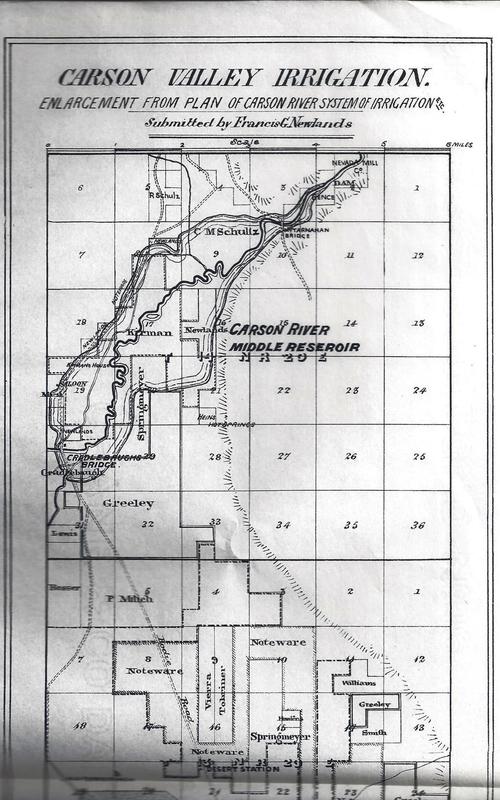
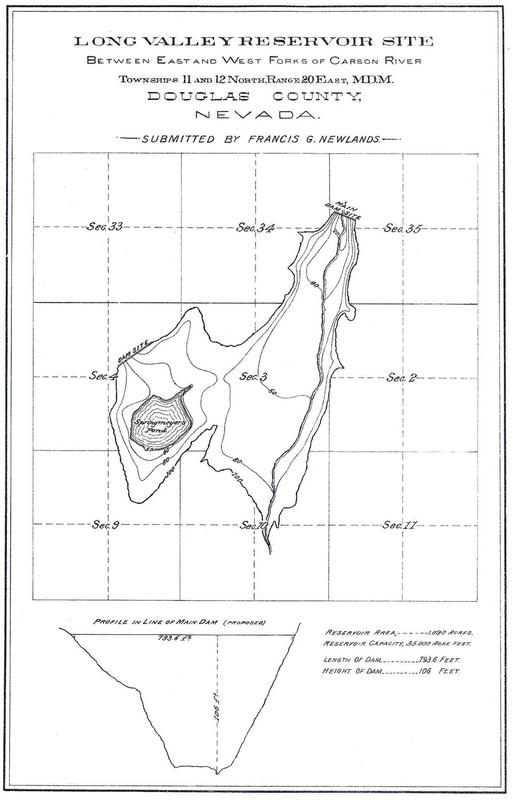
Maps include (examples to right): 1. Plan of Truckee River System of Irrigation and Water Storage 2. Plan of Carson River System of Irrigation and Water Storage 3. Carson Valley Irrigation 4. Long Valley Reservoir Site 5. Plan of Carson River Lower Reservoir 6. Plan of Carson River Middle Reservoir